Observation network Fundamental Survey and Observation
(in the case of about 20 km interval)
Prime Minister's Office
Government of Japan
IntroductionTables and figures:1. Principles of promoting seismic survey and observation
(1) The necessity of seismic survey and observation2. Implementation of Fundamental Survey and Observation
(2) The current status of seismic survey and observation and related issues
(3) Principles of Fundamental Survey and Observation
(4) Promotion of Fundamental Survey and Observation(1) Earthquake observation3. Distribution of results of Fundamental Survey and Observation
(2) Strong motion observation
(3) Observation of crustal deformation (GPS continuous observation)
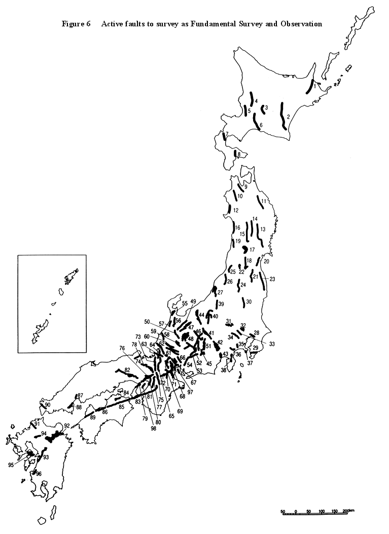
(4) Survey of inland and coastal active faults
(5) Earthquake observation by cable-type ocean-bottom seismometers
(6) Survey of topograpy and active faults in the sea area
(7) Survey of crustal structure(1) The necessity of opening and distribution
(2) Principles of the distribution system of results of seismic survey and observation
(3) Promotion of distribution of results of seismic survey and observation
(4) Promotion of earthquake information transfer on real time bases
Table 1 Active faults to survey as Fundamental Survey and ObservationBack to Tabel of Contents
Table 2 Survey and observation items of which distribution of the result was examined
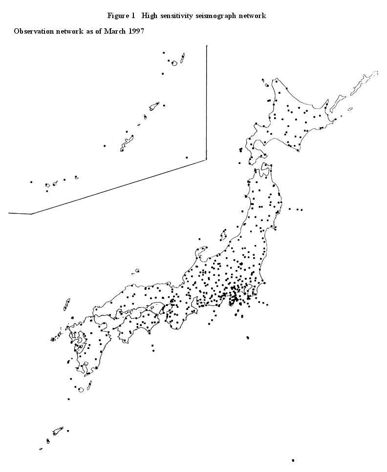
Figure 1 High sensitivity seismograph network
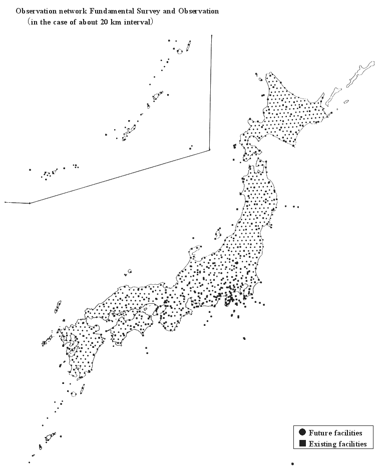
Figure 2 Broadband seismograph network
Figure 3 Strong motion seismograph network (the surface)
Figure 4 Strong motion seismograph network (underground)
Figure 5 GPS continuous observation network
Figure 6 Active faults to survey as Fundamental Survey and Observation
Based on Special Measures Law for Earthquake Disaster Prevention, Subclause 3, Clause 2, Article 7, the Headquarters for Earthquake Research Promotion (the Headquarters) is in charge of planning comprehensive seismic survey and observation.
Since the establishment of the Headquarters in July, 1995, it has examined fundamental seismic survey and observation etc. (Fundamental Survey and Observation), which is a core of comprehensive seismic survey and observation as present issues which should be promoted. The Headquarters made this report regarding the plan of Fundamental Survey and Observation.
Moreover, it is important to consider the followings on putting this plan into action.
�EPromoting Fundamental Survey and Observation, from the comprehensive viewpoint, they have to cooperate with going nationwide, local, and research-oriented survey and observation.Back to Tabel of Contents�EOn putting the plan of Fundamental Survey and Observation into action, related national organizations are cooperate and concrete promotion will be urgently undertaken in the future.
�EThe concrete matter of the plan of Fundamental Survey and Observation will becontinuously examined.
�EConsidering the latest results of science and technology, operational situation, evaluation of execution result, etc., of Fundamental Survey and Observation, a review of this plan will be supposed to be carried out, if necessary.
(1) The necessity of seismic survey and observation
There are few countries where more earthquakes occur than in Japan, and even if it is limited to this century, large earthquakes such as the Kanto Earthquake(1923), the Fukui Earthquake(1948), and the Hyogo-ken Nanbu Earthquake(1995) killed a lot of people. Especially, the Hyogo-ken Nanbu Earthquake, which caused metropolis compound disaster, which was rarely observed recently, such as discontinuity of basic infrastructure such as transportation facilities which supports the city functions, collapse of modern buildings, fire, and refuge in the long term, made the Japanese people widely recognize the necessity of reducing earthquake disaster.
With the aim of reduction of earthquake disaster and understanding earthquakes, seismology in Japan was born at the end of the 19th century. Introducing epoch-making results such as discovery of deep earthquakes and establishment of the fundamental model of focal mechanism, Japanese seismology has fulfilled the leading role in seismology in the world.
Although further development of seismology should be waited for, in order to understand earthquake phenomena which are sudden and instantaneous phenomena, useful information for earthquake disaster reduction can be obtained by seismic survey and observation even at present. For example, with the aim of application to disaster preventive urban planning, etc., effective information to evaluate the long-term possibility of the large earthquake occurrence can be obtained by survey of each active fault. If the damage can be rapidly estimated by observing strong motion immediately just after the earthquake occurrence, appropriate deployment of emergency activities becomes possible. For earthquake disaster reduction, it is necessary to promote these kinds of survey and observation.
For the Japanese people to properly understand earthquakes, and to prepare for an earthquake, it is important to understand crustal activity (seismic activity and crustal movement) and strong motion by survey and observation, and to announce and explain the result. It is also possible that the result of survey and observation also is used for the research on seismic phenomena. It is necessary to promote survey and observation, in order to understand seismic phenomena deeply and widely.
Based on the above, the present theme of which the Headquarters must promote evaluation and understanding, etc. by seismic survey and observation are as follows.
*On crustal activity
�EUnderstanding and evaluation of the present crustal activity�EUnderstanding crustal structure which causes earthquakes
�EUnderstanding earthquake occurrence process in the focal region
�EEvaluation of the long-term possibility of large earthquake occurrence
*On strong motion and tsunami
�EImmediate acquisition of data on strong motion just after the earthquake occurrenceBack to Tabel of Contents�EUnderstanding underground structure which amplifies ground motion at the surface
�EForecasting of strong ground motion
�EImmediate data acquisition regarding tsunami just after the earthquake occurrence
�EEvaluation of the possibility of the occurrence of tsunami earthquakes
(Tsunami earthquakes generate large tsunami comparing with the ground motion because of their slower fault movement than the ordinary earthquake.)
Universities, administrative organizations and others have contributed to promote seismic survey and observation by variety of methods.
However, the importance of survey and observation has been put in observation for preseismic phenomena, and it has not been necessarily sufficient to survey and to observe other phenomena, such as earthquake cycle, energy storage periods which are related to the earthquake occurrence, slow crustal movements after the earthquake occurrence, and strong motion observation just after the earthquake occurrence, so far.
Nationwide survey and observation have not been sufficient, for example, dense earthquake observation network has been limited to the specific region. Survey of underground structure which affects strong motion has not been sufficient either.
On distribution of results of survey and observation, the data has not been sufficiently utilized, because organizations which participate in survey and observation do not have a sufficient service system for users who have various requests concerning period, contents, and formats of data.
In order to understand seismic phenomena, it is appropriate to try to elucidate a series of seismic process in the long period, which is that the crustal strain is accumulated, then released by an earthquake, and after that, it is accumulated again. Therefore, it is appropriate to try to carry out survey and observation for seismic phenomena in the time range as wide as possible, to elucidate whole process of the earthquake cycle at every phase before, at, and after the earthquake occurrence.
The plate motion as a prime force which causes earthquake occurrence, is of the global scale. Japanese archpelago are located on the plate subduction zone where multiple plates collide and is very seismically active. An earthquake is fault motion which occurs beneath the surface. The seismic waves generated by the fault movement is propagated through the basement rock and the surface layer. It causes shaking on the surface which is occasionally strong motion which causes damage. Therefore, it is appropriate to try to carry out survey and observation in the spatial range as uniform as possible, which is land and sea area, surface and underground.
The Headquarters defines survey and observation for earthquakes and related crustal activity, which are carried out in the time range as wide as possible, in the spatial range as uniform as possible, which are fundamental to understand and to evaluate seismic phenomena, as Fundamental Survey and Observation, and try to promote it, considering the situation including finance circumstances in the every year.
With the aim of disaster reduction and understanding seismic phenomena, Fundamental Survey and Observation is carried out for evaluation of the long-term possibility of large earthquake occurrence, understanding and evaluation of the present crustal activity, estimation of strong ground motion, improvement of forecasting of tsunami, and offering of fundamental data for immediate earthquake information transfer etc.. By utilizing results of Fundamental Survey and Observation, development of seismology, earthquake engineering, etc., promotion of related science and technology such as solid-earth science, and construction engineering, are expected.
The results of Fundamental Survey and Observation is supposed to be widely distributed to users such as organizations related to earthquake disaster prevention, the general public, and researchers. Therefore, the results of Fundamental Survey and Observation are opened in principle, and they are tried to be distributed efficiently.
Fundamental Survey and Observation is supposed to be carried out by related administrative organizations in cooperation with universities, for a while, examining the possibility of implementation by local governments.
Observation are supposed to be carried out stably as routine work in the long term (at least several decades).
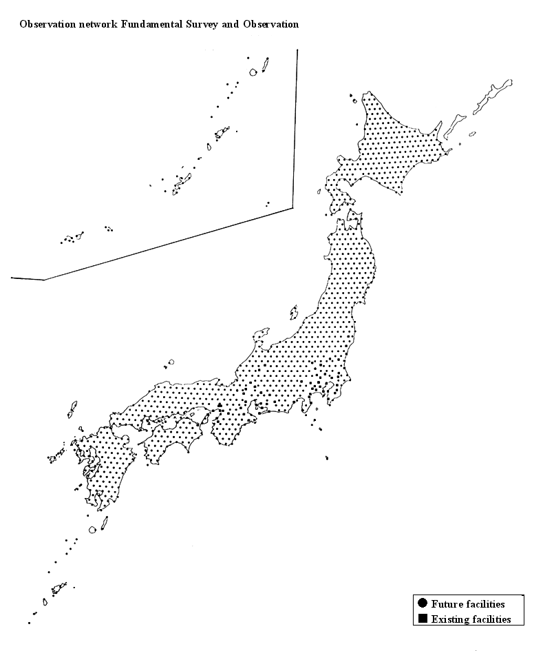
When development of observation network is promoted, existing observation facilities are utilized as much as possible, and new observation facilities will be built in areas where there is no existing facility. After that, the observation facilities, in which it will be difficult to produce stable data in the long term, will be renewed in order.
Fundamental Survey and Observation also produces fundamental data for erthquake research. Moreover, research institutes such as universities are expected to carry out more detailed and various research-oriented survey and observation to understand seismic phenomena.
Based on the principles of Fundamental Survey and Observation and results of survey and observation until now, the Headquarters promotes the followings as Fundamental Survey and Observation.
(1) Earthquake observation
1) Inland earthquake observation by high sensitivity seismographs(Observation of microearthquakes)(2) Strong motion observation2) Inland earthquake observation by broadband seismographs
(3) Observation of crustal deformation (GPS continuous observation)
(4) Survey of inland and coastal active faults
Considering operational situation of fundamental seismic survey and observation, the following survey and observation are tried to be carried out.
(5) Earthquake observation by cable-type ocean-bottom seismometers
(6) Survey of topography and active faults in the sea area
Moreover, the following surveys are examined regarding effectiveness of the technique and methods of operation, etc..
(7) Survey of crustal structure
1) Survey of island arc crustal structureBack to Tabel of Contents2) Survey of underground structure beneath sedimentation plains
3) Survey of crustal structure near the plate boundary
1) Inland earthquake observation by high sensitivity seismographs(Observation of microearthquakes)
<1> Principles
Dense earthquake observation network by high sensitivity seismographs makes accuracy of determination of hypocenters and the focal mechanism an expression of applied force that generate earthquakes of inland earthquakes better, and contribute to understanding the rupture zone. This synthetic evaluation is expected to contribute to accumlating knowledge regarding the plate structure, the crustal structure, the seismicity pattern, and change of crustal stress.
Size of inland earthquake usually corresponds to fault area (length and width) and displacement at the fault. Even if the fault length and displacement are not able to be estimated, if maximum depth at which inland earthquakes occur is able to be estimated by earthquake observation by high sensitivity seismographs, it is expected to evaluate possible largest fault width empirically, and to contribute to estimation of maximum size of earthquakes in each region empirically. From this point of view, it is appropriate to determine the density of inland earthquake observation network by high sensitivity seismographs.
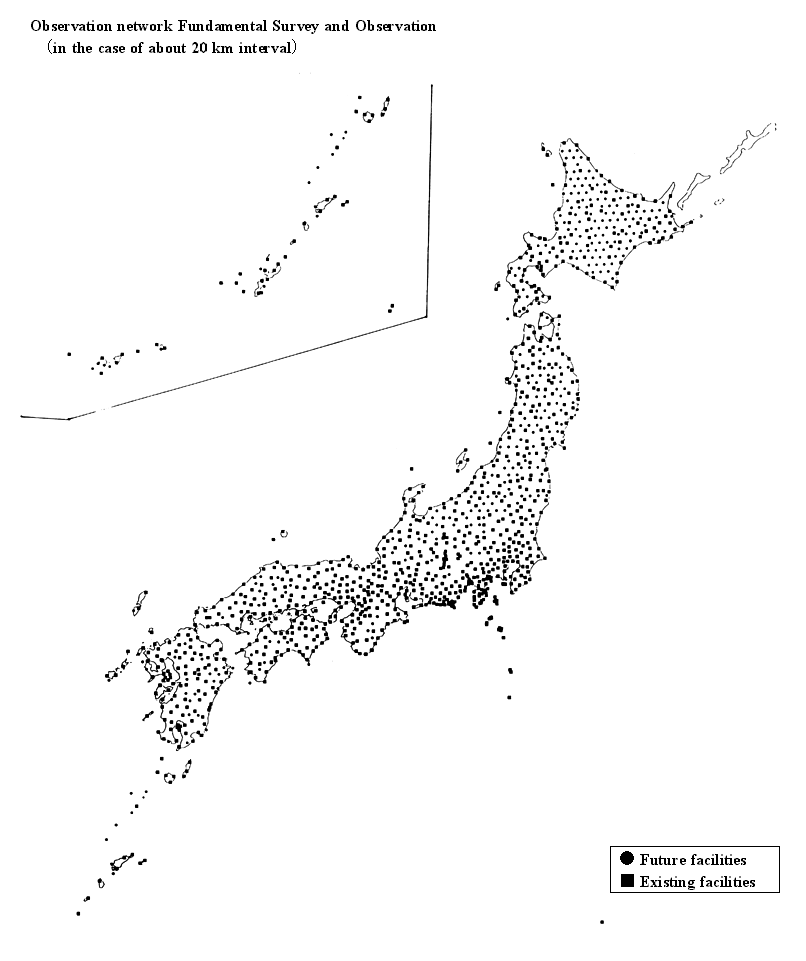
It is known that inland earthquakes normally occur in the inland upper crust, which is shallower than depth of 15 to 20 km, empirically. Generally, in order to precisely estimate depth of the hypocenter, intervals between adjacent seismic stations are desirable to be comparable to the depth of the hypocenter. Therefore, at present, the Headquarters believes that it is appropriate to try to promote development of nationwide earthquake observation network consists of high sensitivity seismographs at standard intervals between 15 and 20 km.
<2> The current status of observation
In Japan, the earthquake observation by high sensitivity seismographs is carried out at about 600 observation facilities, which belong to Urgent Earthquake and Tsunami Detection Network installed by Japan Meteorological Agency, microearthquake observation networks installed by universities, National Research Institute for Earth Science and Disaster Prevention in Science and Technology Agency, etc. in each region.
Urgent Earthquake and Tsunami Detection Network is the nationwide network consists of approximately 150 stations uniformly distributed. Because of the purpose, the density of the stations is low and most noise levels are not low enough to detect microearthquakes.
On the other hand, microearthquake observation networks installed by universities, National Research Institute for Earth Science and Disaster Prevention, etc., cover the specific regions.
From the above, it is clear that nationwide and uniformly distributed observation network to detect microearthquakes does not exist now.
Science and Technology Agency is installing high sensitivity seismographs as Fundamental Survey and Observation.
<3> The plan from now on
At present, the Headquarters tries to promote development of the nationwide seismic observation network consists of high sensitivity seismographs at standard intervals of between 15 and 20 km.
On promoting development of earthquake observation network of high sensitivity seismographs, existing observation facilities will be utilized as much as possible.
In site selection of observation facilities, it is considered to use islands efficiently, and not to array linearly as much as possible. Furthermore site selection, determination of the order of installing facilities, etc., will be scheduled.
On installing seismographs, in order to avoid the noise, etc., the observation well (vertical hole) will be made in principle as possible, they will be installed at the bottom of the hole on the basement rock. On making observation well, the necessary physical constant ( P wave velocity, S wave velocity, etc.) of the underground will be surveyed. Furthermore, the strong-motion seismograph will be installed together if possible. It is designed to observe the strong motion while high sensitivity seismographs are saturated by the strong motion.
2) Inland earthquake observation by broadband seismographs
<1> Principles
Observation networks of broadband seismographs, which detect seismic waves of broadband frequency, contributes to elucidation of the focal mechanism and of the rupture process of earthquakes larger than small earthquakes (about 3 in Richter scale). This synthetic evaluation of results of survey and observation is expected to contribute to understanding of complexity and variety of the focal region systematically , and to elucidation of the plate structure and the crustal structure.
From the observation network of broadband seismographs, it is expected to estimate size of the earthquake and the direction of rupture propagation along the fault immediately, to specify more disastrous region, and to give information to develop disaster prevention activity effectively. Furthermore the observation network of broadband seismographs contributes to detection and elucidation of tsunami earthquakes.
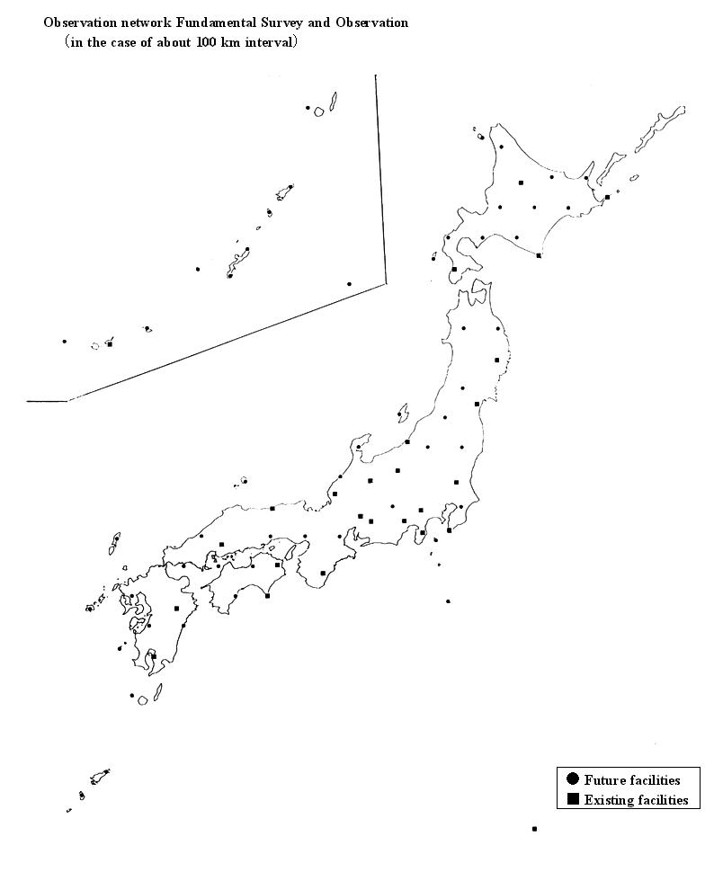
It is desirable that there are observation facilities all around the epicenter, and that these facilities are located where the direct waves of the earthquake are able to be observed, to accurately estimate the rupture process. Therefore, it is appropriate to try to promote development of the earthquake observation network of broadband seismographs at standard intervals of about 100 km.
<2> The current status of observation
In Japan, there are about 20 broadband seismographs operated by universities and other institutes. Their frequency ranges cover those from small earthquakes to free oscillation of the earth. These observation facilities are mainly located in Kanto and Tokai region, and nationwide and uniformly distributed observation network does not exist.
Science and Technology Agency is installing broadband seismographs as Fundamental Survey and Observation.
<3> The plan from now on
The Headquarters tries to promote development of the nationwide earthquake observation network of broadband seismographs at standard intervals of about 100 km.
On promoting the development of the network, existing facilities and pits for observation will be utilized as much as possible.
In site selection of observation facilities, it is considered to use islands efficiently, and not to array linearly as much as possible. Furthermore site selection, determination of the order of installing facilities, etc., will be scheduled.
Since the broadband seismograph is saturated by the strong motion,
the strong-motion seismograph will be installed near the broadband seismograph,
if possible.
1) Principles
Observation networks by strong-motion seismographs (the seismograph which observes strong shaking) contributes to estimate intensity of earthquake ground motion, period, duration time, and spatial distribution of strong motion, and to elucidation of the rupture process in the focal region in detail. Furthermore by clarifying effect of surface layers on earthquake ground motion, it is expected to contribute to estimation of strong motion.
The observation network of strong-motion seismographs is expected to observe strong motion immediately, to specify disastrous region, and to give information to develop disaster prevention activity effectively.
Because the underground structure is very heterogeneous, earthquake ground motion is locally variable. Especially, because sedimentary surface layer on the basement rock is very heterogeneous, earthquake motion is amplified very complexly and locally there. Therefore in order to understand the property of earthquake ground motion, it is useful to observe seismic waves on the basement rock which is less heterogeneous than the surface layer, and to systematically investigate earthquake motion generated at the focal region, and response characteristic to earthquake motion in the surface layer. Because ground motion on the basement rock is affected by reflected waves etc., in order to remove this effect, it is desirable to observe ground motion on the surface simultaneously near the strong-motion seismograph under the ground.
The strong-motion seismograph will be installed on the basement rock as much as possible with the high sensitivity seismograph which will be installed at standard intervals between 15 and 20 km, and existing strong-motion seismographs on the surface are utilized. By this, it is expected to observe ground motion near the focal region of the large inland shallow earthquake surely, and to investigate response characteristics of the ground and heterogeneous structure of the underground.
2) The current status of observation
There are several thousands of strong-motion seismographs of National Research Institute for Earth Science and Disaster Prevention, Japan Meteorological Agency, Ministry of Construction, the local government, etc.. Moreover there are many strong-motion seismographs of private companies such as railroad companies, gas companies, electric companies, and construction companies.
Many of these strong-motion seismographs are on the surface. Observation on the basement rock is not enough.
Science and Technology Agency is installing strong-motion seismographs on the basement rock as Fundamental Survey and Observation.
3) The plan from now on
Strong-motion seismographs will be installed on the basement rock
as much as possible together with high sensitivity seismographs. Moreover
the existing nationwide and uniformly distributed observation network of
strong-motion seismographs (about 1600 facilities) on the
surface operated by National Research Institute for Earth Science and Disaster
Prevention and Japan Meteorological Agency, will be utilized. Furthermore
the new facility on the basement rock and that on the surface are arranged
to be close with each other. Results of the observation by other existing
strong-motion seismographs of the national government, local governments,
etc., will be tried to be distributed, in order to utilize the observation
result effectively.
1) Principles
In order to elucidate what cause earthquakes, and to evaluate their time and spatial variation widely, it is necessary to observe crustal strain widely. Dense GPS (Global Positioning System) continuous observation network contributes to understanding of time and spatial variation of crustal strain immediately, routinely, and widely. Moreover, by the GPS continuous observation network, knowledge of strain accumulation which results in earthquake occurrence is expected to be accumulated.
Crustal strain is accumulated annually on the order of 10�|�V all over the country, excluding areas where crustal deformation is especially remarkable. In order to detect this strain accumulation by distance measurement between 2 observation facilities, considering the observation error, at present, the Headquarters believes that it is appropriate to promote development of the nationwide and uniformly distributed GPS continuous observation network at standard intervals between 20 and 25 km. Because the dense GPS continuous observation also immediately observe crustal deformation after the earthquakes, fundamental knowledge of the process of the earthquake occurrence is expected.
Moreover, in order to contribute to observation of time and spatial variation of crustal strain in the sea area, it is also considered to install GPS continuous observation facilities on the island (including the shore reef, if possible), etc..
2) The current status of observation
There are about a thousand GPS continuous observation facilities of Geographical Survey Institute in Ministry of Construction, etc..
Geographical Survey Institute and Science and Technology Agency are installing GPS continuous observation facilities as Fundamental Survey and Observation.
3) The plan from now on
At present, the Headquarters tries to promote development of the
GPS continuous observation network at standard intervals between 20 and
25 km. On promoting development of the GPS, existing observation facilities
will be utilized as much as possible. In site selection of observation
facilities, uniform distribution is aimed at, and it is also considered
to use islands efficiently.
1) Principles
Because active faults are vestiges of past inland large earthquakes, and have the potential to become active again in the future, survey of active faults is important means to evaluate the possibility of inland large earthquake occurrence.
That is to say, it is effective to survey the location of active faults for evaluating the possible location of inland large earthquake occurrence. Furthermore, it is effective to survey the time of past large events of active faults for the long term evaluation of inland large earthquake occurrence. Moreover, size of earthquakes resulting from the fault movement is related to length and displacement of active faults, therefore it is effective to survey them for evaluating magnitude of inland large earthquakes.
In Japan, a lot of active faults are distributed. In order to objectively evaluate earthquakes caused by fault movement in the future, it is important to accumulate fundamental data on each active fault all over the country. In order to efficiently carry out survey of active faults, it is important to select active faults to survey, and to obtain information necessary for evaluating magnitude and time of hypothetical earthquakes.
It is appropriate to select active faults to survey from those of which activities seem to enormously affect from the social and economic view points. Concretely, active faults to be surveyed are selected from these of which certainty isI�T or II, and of which activity is A or B in "Active Faults in Japan revised edition" (University of Tokyo Press, 1991) in principle. Moreover, active faults to be surveyed should satisfy one of the following standards.
I) Length is longer than 20 km.
II) In the case of active faults shorter than 10km, those active faults of which strike is almost the same, adjoin each other within 5 km, and they form active fault zone (group) longer than 20 km.
III) In the case of active faults whose length is 10 to 20km, there are other active faults (zone, group) within 10 km, of which strike is almost the same, and of which length is longer than 10 km, and active fault zone (group) longer than 20 km is formed as a whole with adjoining.
Furthermore, in the case where it is necessary to reexamine the data to be used in the selection because of insufficiency of the data, geological condition etc., and where length of active faults including its extended part to coastal area estimated longer than 20 km, those conditions are inspected in the selection of active faults to be surveyed.
In order to evaluate long-term possibility of hypothetical large earthquake occurrence, the following survey is considered to be necessary.
I) Accurate location
II) Mean slip rate
III) The time of the past activity(time interval and the latest activity time)
IV) Displacement and length of the fault corresponding to one earthquake
V) Underground structure around the fault
Moreover, it is necessary to review selected faults to be surveyed as Fundamental Survey and Observation and contents of survey, considering improvement of method of survey and new knowledge of active faults in the future.
2) The current status of survey
The location and activity, which means the degree of activity of the fault, of most inland active faults are grasped except for those in the plains. The location of most main coastal active faults is surveyed by acoustic exploration. Furthermore, activity of some main coastal active faults, for example in the inland sea, is grasped, but coastal areas, in which data with appropriate accuracy are obtained, are limited very much. There are possible cases to evaluate the location and magnitude of large earthquake in the future, based on the results of survey and research so far. However, in the present stage, it is hard to say that there is sufficient information necessary to evaluate long-term possibility of large earthquake occurrence, including time, all over the country.
The following survey are being carried out as Fundamental Survey and Observation. Geological Survey of Agency of Industrial Science and Technology in the Ministry of International Trade and Industry, Science and Technology Agency (local governments), etc. are carrying out survey of main inland active faults. Geographical Survey Institute is carrying out survey of the detailed location of active faults in urban areas. Furthermore, Geological Survey of Japan and Hydrographic Department of Maritime Safety Agency are partially carrying out some survey and researches, including the detail location, activity, and history, of main coastal active faults.
3) The plan from now on
Based on the principles, the Headquarters tries to promote survey
of inland and coastal active faults in Table 1.
1) Principles
Many destructive earthquakes occur near the plate boundary in the sea area around Japan. Because the area in which the oceanic plate subducts under the inland from trench or trough, where the depth of the plate boundary is shallower than 50km, has especially high possibility to cause great earthquakes, it is important to underdstand the seismic activity in this sea area. Because the inland earthquake observation network by high sensitivity seismographs is far from the hypocenter and seismic waves travel through complicated structure, it is difficult in principle to accurately estimate depth of the hypocenter, and generally the epicenter has systematic error. Therefore it is desirable to install seismometers on the bottom of the sea for acculate observation of earthquakes in the sea area.
The Headquarters believe that observation by cable-type ocean-bottom seismometers is effective to get stable data in the long-term from seismometers on the bottom of the sea. Furthermore, by installing tsunami sensors with seismometers, it is possible to contribute to elucidation of tsunami phenomena and improvement of tsunami forecasting.
There are various problems to install cable-type ocean-bottom seismometers, but considering the location and depth of interplate earthquake occurrence, it is desirable to lay cables over the hypothetical focal regions (to the region near the trench axis in the Pacific Ocean), and to distribute seismometers in plain aiming at horizontal intervals of 20 km. Furthermore, it is desirable to construct observation system with broadband and wide dynamic range as well as inland seismic observation.
Regarding the cable-type ocean-bottom seismometers, from the viewpoint of effective promotion, the Headquarters believes that it is appropriate to select the region and to try to install them.
2) The current status of observation
Observation by cable-type ocean-bottom seismometers is carried out by Japan Meteorological Agency, National Research Institute for Earth Science and Disaster Prevention, universities, and Japan Marine Science and Technology Center, in the areas off Tokai, off Boso, off Ito, in Sagami Bay, off Sanriku, and off cape Muroto.
The cable-type observation systems, which were recently installed in Sagami Bay etc., have strong-motion seismometers with high sensitivity seismographs. Furthermore, some of cable-type observation systems have tsunami sensors off the shore, which are sensitive pressure sensos.
Japan Marine Science and Technology Center is installing cable-type ocean-bottom seismometers.
3) The plan from now on
At present, existing cable-type ocean-bottom seismometers will be
utilized, and the Headquarters tries to promote development of observation
system with broadband and wide dynamic range in the region which the Headquarters
selects from main sea area one by one, while operational situation of Fundamental
Survey and Observation and so on are taken into consideration. It is considered
to install tsunami sensors etc. too in the cable-type observation systems.
1) Principles
Because active faults in the sea area including the plate boundary have the potential to become active again in the future, similarly to inland active faults, survey of the topography and active faults in the sea area is effective to evaluate earthquake occurrence.
In order to contribute to grasp of the detailed location, topography and activity of active faults in the sea area, the Headquarters believes that it is also useful to carry out detailed topographical survey of the tectonic relief in the sea area, bathymetric survey of the ocean floor with ultrasonic waves, high resolution seismic exploration (the method to survey underground structure with artificial elastic waves), and so on.
Furthermore, in order to elucidate when each active fault caused the large earthquake, it is desirable to determine age of the stratum by sampling sediment around active faults.
In the case of faults widely distributed near the plate boundary, it is especially useful to elucidate relationship of each fault and regularity of activity, in order to understand seismic activity and crustal movement.
In order to topography and active faults in the sea area efficiently, it is desirable to carry out the survey, investigating existing data.
2) The current status of survey
The outline of the geological feature is clear in almost all the sea area around the Japanese Island, and distribution of main faults, which probably caused large earthquakes for last 1 or 2 million years, is summarized as an active fault map. However, resolution of these data is not sufficient, and their activities have been rarely elucidated. Furthermore, it is known that many active faults are distributed near the plate boundary in the region from trench axis to the area several tens km landward, however it is not elucidated how these fault zones cause large earthquakes in relation to each other.
Hydrographic Department of Maritime Safety Agency is carrying out topographical survey and Geological Survey of Japan is doing geological survey and others.
3) The plan from now on
At present, the Headquarters tries to carry out survey of topography and active faults, selecting in the region from the high seismicity sea area one by one, while operational situation of Fundamental Survey and Observation are taken into consideration.
Moreover, in the region where an inland active fault extends to the sea area, surveys will be carried out in cooperation with each other.
In order to promote efficient survey, the Headquarters tries to utilize
existing data such as geophysical exploration of which the purpose is survey
of natural resources.
In order to elucidate and evaluate seismic phenomena, it is useful to understand crustal structure which affect earthquake occurrence and propagation of seismic waves.
Therefore, on survey of crustal structure, it is desirable to examine effectiveness of survey method, ideal way of the execution, etc.. The Headquarters examine carrying out the following surveys of crustal structure, while operational situation of Fundamental Survey and Observation are taken into consideration.
1) Survey of island arc crustal structure
2) Survey of underground structure on alluvial plains
3) Survey of crustal structure near the plate boundary
1) Survey of island arc crustal structure
<1> Principles
By survey of active faults and GPS continuous observation of Fundamental Survey and Observation, knowledge of an active fault and crustal deformation is increasing steadily. In order to connect these knowledge of surface deformation with elucidation of earthquake occurrence mechanism, it is useful to get knowledge of crustal structure down to the depth in which shallow earthquakes actually occur, and of geometrical structure of underground faults.
Therefore, it is considered that structure of the cross section down to the bottom of the island arc crust is surveyed in detail.
<2> The current status of survey
Survey of crustal structure have been carried out in some areas so far. However, in Japan, systematic seismic profiling has never been carried out to elucidate crustal structure to the bottom of the crust on large scale and with high resolution.
<3> The plan from now on
The Headquarters examines to carry out seismic exploration with controlled seismic source, on large scale and with high resolution, on the profile line including the sea area which crosses the Japanese Island, while evaluating the situation of grasp of crustal structure. Moreover, it is examined that other kind of exploration is carried out simultaneously, if necessary.
2) Survey of underground structure on sedimentary plains
<1> Principles
For it is said that one of the causes of the earthquake disaster belt in Hyogo-ken Nanbu Earthquake is the three-dimensional topography of underground structure in Kobe region, it is useful to get knowledge of underground structure to estimate strong ground motion. High populated urban areas in Japan is generally located on large plains and basins. Therefore survey of three-dimensional underground structure from the surface to the basement rock is able to produce basic data for estimation of strong ground motion from the viewpoint of disaster reduction. Furthermore, it is considered that these data can be utilized to examine faults under large plains.
<2> The current status of survey
Some kinds of survey of structure under plains have been carried out mainly by local governments in some areas, and information are partially obtained. However, survey have never been systematically carried out to grasp three-dimensional underground structure over plain, which is necessary for quatitative evaluation of strong ground motion.
<3> The plan from now on
It is examined to carry out survey of underground structure by seismic exploration, on large plains which have faults of high activity around them, and especially on plains in urban areas of high population density. Before carrying out survey, it is necessary to consider to collect existing data of deep boring and so on, and to examine appropriate methods of survey in every target areas.
3) Survey of crustal structure near the plate boundary
<1> Principles
In order to elucidate occurrence mechanisms of interplate earthquakes in detail, and to evaluate possibility of the large earthquake occurrence, it is useful to get knowledge of crustal structure under the sea bottom near the plate boundary. Moreover, it is estimated that dynamic coupling at the plate boundary is spatially inhomogeneous, and it is considered that detail information of crustal structure near the plate boundary contributes to understanding of this kind of inhomogeneous structure.
<2> The current status of survey
It is elucidated that the oceanic plate with oceanic crust subducts under the island arc crust on the island arc side near the trench axis where interplate earthquakes occur, and that this structure is very different regionally. However, because 3-dimensional structure has never been elucidated so far, inhomogeneous structure, which is able to be compared with seismic pattern of interplate earthquakes, has not been elucidated.
<3> The plan from now on
The Headquarters examines to carry out seismic exploration with controlled seismic source on a large scale, to survey crustal structure deeper than 10 km under the sea bottom, which is considered to be the focal region of interplate earthquakes, on the profile lines over
the target area, while evaluating the situation of understanding
of crustal structure. Moreover, it is examined that other kind of exploration
is carried out simultaneously, if necessary.
(1) The necessity of opening and distribution
The results of Fundamental Survey and Observation are considered to be utilized widely by the following users for disaster reduction and understanding seismic phenomena.
By using the results of survey and observation, the Headquarters is able to examine present seismic activity and long-term possibility of the large earthquake occurrence etc., and is able to promote comprehensive evaluation of seismic phenomena.
By using the results of survey and observation, organizations related to earthquake disaster prevention of the national government and local governments are able to obtain earthquake information immediately just after the earthquake occurrence, and are able to try to reduce disaster.
By offering the results of survey and observation and giving public relations about them to the public, it is expected to be able to support the public to think about an earthquake and to face earthquakes appropriately. In this case, in order for the public to be able to understand earthquake phenomena correctly, it is necessary to offer accurate and understandable information, for example, by explaining observation condition, relation with other observation data, data precision, data quality, etc..
By using the results of survey and observation, researchers promote their research.
In order to contribute these kinds of activities of organizations,
the public, and researchers, the results of Fundamental Survey and Observation
are opened in principle, and they are tried to be distributed smoothly.
On distribution, such as collection, processing, and offers, of the results of survey and observation, it is desirable to develop the data center function, and to carry out it smoothly.
The data center function is not necessarily in one organization. It is possible that every distribution functions, such as collection function, processing function, and offer function, or every observation items, functions are separated into sub-centers, (including functions in existing organizations), and that they play a role of a data center as a whole. On functions which are not in existing organizations, it is desirable to develop sub data center function which supplement them, if necessary.
Data center functions, which promote distribution of the results of survey and observation, are desirable to be the following.
1) The data collection function and the data processing function
("The data processing center")
<1> Quick processing row data
<2> Quick offering row data and processed data to Earthquake Research Committee under The Headquarters
<3> Quick transfer of row data and processed data to "The data distribution center"
2) The data offer function ("The data distribution center")
<1> Development, maintenance, and administration of comprehensive database
<2> Quick offering comprehensive data to Earthquake Research Committee
<3> Quick offering comprehensive data to other users
The followings are considered conditions which comprehensive database should have.
<1> Available are complete data set which are useful at every stage of dataprocessing and reference data set such as topographical data.
<2> Data are homogeneous as much as possible in the time and space domain.
<3> Data are digital as much as possible.
<4> Necessary data regarding precision and quality of data are available.
<5> Usable display utilities dealing with data are available.
<6> Data format, program, and utilities are unified as
much as possible.
It is desirable that the items in table 2 are promoted to be distributed, at present. They are results of Fundamental Survey and Observation. It is considered that ideal ways of distribution including collection, processing, and offers, of each item are as follows.
1) The high sensitivity seismograph
Waveform data observed by high sensitivity seismographs of Fundamental Survey and Observation are transferred to the data processing center of the high sensitivity seismograph on real time bases. Using waveform data, routine work (reading P and S phases, etc.) is steadily carried out, and hypocenter parameters (origin time, hypocenter, magnitude) and the mechanism solution are determined for earthquakes occurred in and near Japan.
The data distribution center of the high sensitivity seismograph try to make these databases, and to construct the system which rapidly respond to user's requirements.
2) The broadband seismograph
Waveform data observed by broadband seismographs of Fundamental Survey and Observation are transferred to the data processing center of the broadband seismograph on real time bases. Using waveform data, the focal mechanism and the source time function (time variable of fault rupture) are suitably determined for earthquakes larger than a certain magnitude occurred in and near Japan.
The data distribution center of the broadband seismograph try to make these databases, and to construct the system which rapidly respond to user's requirements.
3) The strong-motion seismograph
Waveform data observed by strong-motion seismographs of Fundamental Survey and Observation are transferred to the data distribution center of the strong-motion seismograph and some data processing centers which need these data.
The data distribution center of the strong-motion seismograph try to make databases of waveform etc., and to construct the system which rapidly respond to user's requirements. It is tried to construct and to maintain the system which is able to open waveform data observed by strong-motion seismographs as soon as possible after the earthquake occurrence. One purpose of strong-motion seismographs is supplementary for saturated high sensitivity seismographs and broadband seismographs. In this case, waveform data are rapidly collected and transferred to the data processing center of the high sensitivity seismograph and the data processing center of the broadband seismograph.
It is considered to be necessary to promote comprehensive analysis in order to elucidate strong motion using data observed by existing strong-motion seismographs in addition to those of Fundamental Survey and Observation. Therefore, it is examined the way to promote to distribute strong motion data observed by seismic intensity observation systems of local governments etc..
4) GPS continuous observation
Data observed by GPS continuous observation facilities of Fundamental Survey and Observation are transferred to the data processing center of GPS continuous observation. These data are rapidly processed, and time series data are routinely analyzed.
The data distribution center of GPS continuous observation try to make data into usable form, and to offer these data by media suitable to data quantity etc..
It is examined the way to promote to distribute data observed by GPS continuous observation facilities other than those of Fundamental Survey and Observation, in response to user's requirements.
5) Survey of the active fault
The results of survey of active faults of Fundamental Survey and Observation are collected at the data distribution center of survey of the active fault.
The data distribution center of survey of the active fault make the database with data format as systematic as possible. When the Headquarters evaluates the active fault so on, the database is renewed one after another. Furthermore, it is examined to construct the system which is able to search the database for reference to related figures, historical earthquakes, etc..
Moreover, in addition to the results of Fundamental Survey and Observation,
it is desirable to promote to collect, store, and distribute the results
of other various seismic survey and observation, the results of foreign
survey and observation mainly around Japan, and the results of survey and
observation in the past. Furthermore, it is also desirable to promote to
utilize and distribute the results of survey and observation of specific
purpose other than earthquake research, such as geophysical exploration
for survey of natural resources or survey of the ground.
Prompt distribution of the results of survey and observation of the occurred earthquake to organizations related to earthquake disaster prevention of the national government and local governments and the following prompt decision of appropriate emergency responses are expected to contribute to reduce earthquake disaster.
Japan Meteorological Agency, local governments, and private enterprises are developing the system for accurate data acquisition concerning a regional distribution of seismic intensity etc. immediately after the earthquake occurrence.
Trying to cooperate with these systems, it is examined to construct
the system which immediately collects data observed by high sensitivity
seismographs, broadband seismographs, strong-motion seismographs, cable-type
ocean-bottom seismometers, and tsunami sensors of Fundamental Survey and
Observation, which immediately determine earthquake information in detail,
and then immediately transfer it to organizations related to earthquake
disaster prevention on real time bases.
Table 1 Active faults to survey as Fundamental
Survey and Observation
|
1
|
Shibetsu fault zone |
|
2
|
Tokachi-heiya fault zone |
|
3
|
Furano fault zone |
|
4
|
Mashike-sanchi-toen fault zone |
|
5
|
Tobetsu fault |
|
6
|
Ishikari-teichi-toen fault zone |
|
7
|
Kuromatsunai-teichi fault zone |
|
8
|
Hakodate-heiya-seien fault zone |
|
9
|
Aomori-wan-seigan fault zone |
|
10
|
Tsugaru-sanchi-seien fault zone |
|
11
|
0rizume fault |
|
12
|
Noshiro fault |
|
13
|
Ktakami-teichi-seien fault zone |
|
14
|
Shizukuishi-bonchi-seien Mahiru-sanchi-toen fault zone |
|
15
|
Yokote-bonchi-toen fault zone |
|
16
|
Ktayuri fault |
|
17
|
Shinjo-bonchi fault zone |
|
18
|
Yamagata-bonchi fault zone |
|
19
|
Shonai-heiya-toen fault zone |
|
20
|
Nagamachi-Rifu-gen fault zone |
|
21
|
Fukushima-bonchi-seien fault zone |
|
22
|
Nagai-bonchi-seien fault zone |
|
23
|
Futaba fault |
|
24
|
Aizu-bonchi-seien fault zone |
|
25
|
Kushigata-sanmyaku fault zone |
|
26
|
Tsukioka fault zone |
|
27
|
Nagaoka-heiya-seien fault zone |
|
28
|
Tokyo-wan-hokuen fault zone |
|
29
|
Kamogawa-teichi fault zone |
|
30
|
Sekiya fault |
|
31
|
Kanto-heiya-hokuseien fault zone |
|
32
|
Motoarakawa fault zone |
|
33
|
Arakawa fault |
|
34
|
Tachikawa fault zone |
|
35
|
Isehara fault |
|
36
|
Kannawa/Kouzu-Matsuda fault zone |
|
37
|
Miura-hanto fault group |
|
38
|
Kitaizu fault zone |
|
39
|
Toukamachi fault zone |
|
40
|
Shinanogawa fault zone |
|
41
|
Itoigawa Shizuoka-kozosen fault zone (Chubu) |
|
42
|
Itoigawa Shizuoka-kozosen fault zone (Nanbu) |
|
43
|
Fujikawa-kako fault zone |
|
44
|
Itoigawa Shizuoka-kozosen fault zone (Hokubu) |
|
45
|
Kiso-sanmyaku seien fault zone |
|
46
|
Sakai-toge/Kamiya fault zone |
|
47
|
Atotsugawa fault |
|
48
|
Takayama/Ohara fault zone . |
|
49
|
Ushikubi fault |
|
50
|
Shokawa fault zone |
|
51
|
Inadani fault zone |
|
52
|
Adera fault zone |
|
53
|
Byoubu-yama/Ena-san fault zone |
|
54
|
Sanage-yama fault zone |
|
55
|
Ouchigata fault zone |
|
56
|
Tonami-heiya fault zone |
|
57
|
Morimoto/Togashi fault zone |
|
58
|
Fukui-heiya toen fault zone |
|
59
|
Nagaragawa-joryu fault zone |
|
60
|
Nobi fault zone |
|
61
|
Sekigahara fault zone |
|
62
|
Yanagase fault zone |
|
63
|
Nosaka/Shufukuji fault zone |
|
64
|
Kohoku-sanchi fault zone |
|
65
|
Biwako-seigan fault zone |
|
66
|
Gifu-Ichinomiya fault zone |
|
67
|
Yoro-Kuwana-Yokkaichi fault zone |
|
68
|
Suzuka-toen fault zone |
|
69
|
Suzuka-seien fault zone |
|
70
|
Tongul fault |
|
71
|
Nunobiki-sanchi-toen fault zone |
|
72
|
Kizugawa fault zone |
|
73
|
Mikata/Hanaore fault zone |
|
74
|
Yamada fault |
|
75
|
Kyoto-bonchi Nara-bonchi fault zone |
|
76
|
Arima-Takatsuki fault zone |
|
77
|
Ikoma fault zone |
|
78
|
Mitoke/Kyoto-nishiyama fault zone |
|
79
|
Rokko/Awaji-shima fault zone |
|
80
|
Uemachi fault zone |
|
81
|
Chuo-kozosen fault zone (Izumi-sanmyaku nanen Kongou-sanchi-toen) |
|
82
|
Yamasaki fault zone |
|
83
|
Chuo-kozosen fault zone (Awaji-shima nanbu) |
|
84
|
Nagao fault zone |
|
85
|
Chuo-kozosen fault zone (Sanuki-sanmyaku nanen) |
|
86
|
Chuo-kozosen fault zone (Ishizuchi-sanmyaku hokuen) |
|
87
|
Itsukaichi fault |
|
88
|
Iwakuni fault zone |
|
89
|
Chuo-kozosen fault zone (Ehime hokuseibu) |
|
90
|
Kikukawa fault |
|
91
|
Nishiyama fault zone |
|
92
|
Beppu Hane-yama fault zone |
|
93
|
Futagawa/Hinagu fault zone |
|
94
|
Minoo fault zone |
|
95
|
Unzen fault group |
|
96
|
Izumi fault zone |
|
97
|
Ise-wan fault zone |
|
98
|
Osaka-wan fault zone |
|
|
|
|
| Observation by
high sensitivity seismographs |
Continuous data
Event data |
P wave and S wave arrival
times
Hypocenter parameters Focal mechanism (Mechanism solution) |
| Observation by
broadband seismographs |
Continuous data
Event data |
Focal mechanism (CMT
solution)
Source time function |
| Observation by
strong-motion seismographs |
Event data | |
| GPS continuous observation | Phase data | Time series data |
| Survey of active faults |
|
The result of trenching
The result of geophysical exploration |
Observation network as of March 1997 Observation network Fundamental Survey and Observation (in the case of about 20 km interval)
Observation network as of March 1997 
Observation network Fundamental Survey and Observation (in the case of about 100 km interval)
Observation network as of March 1997
Observation network as of March 1997 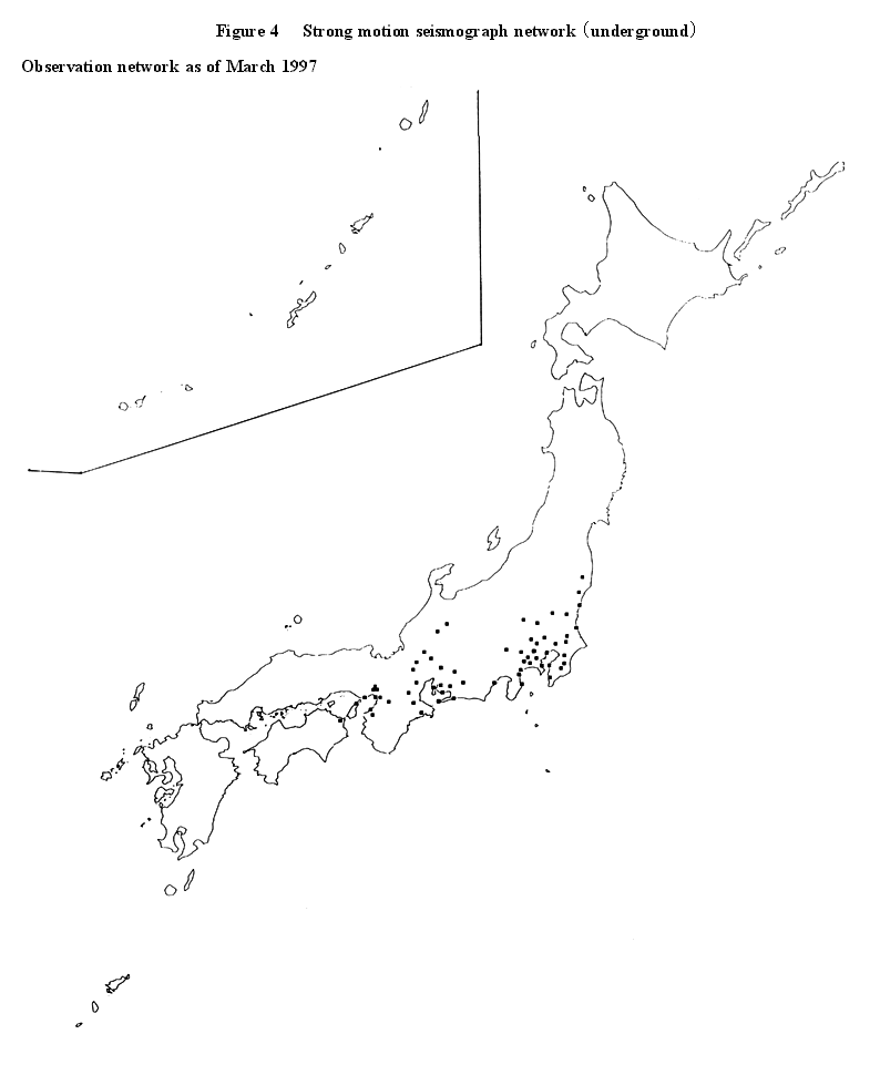
Observation network Fundamental Survey and Observation
Observation network as of March 1997 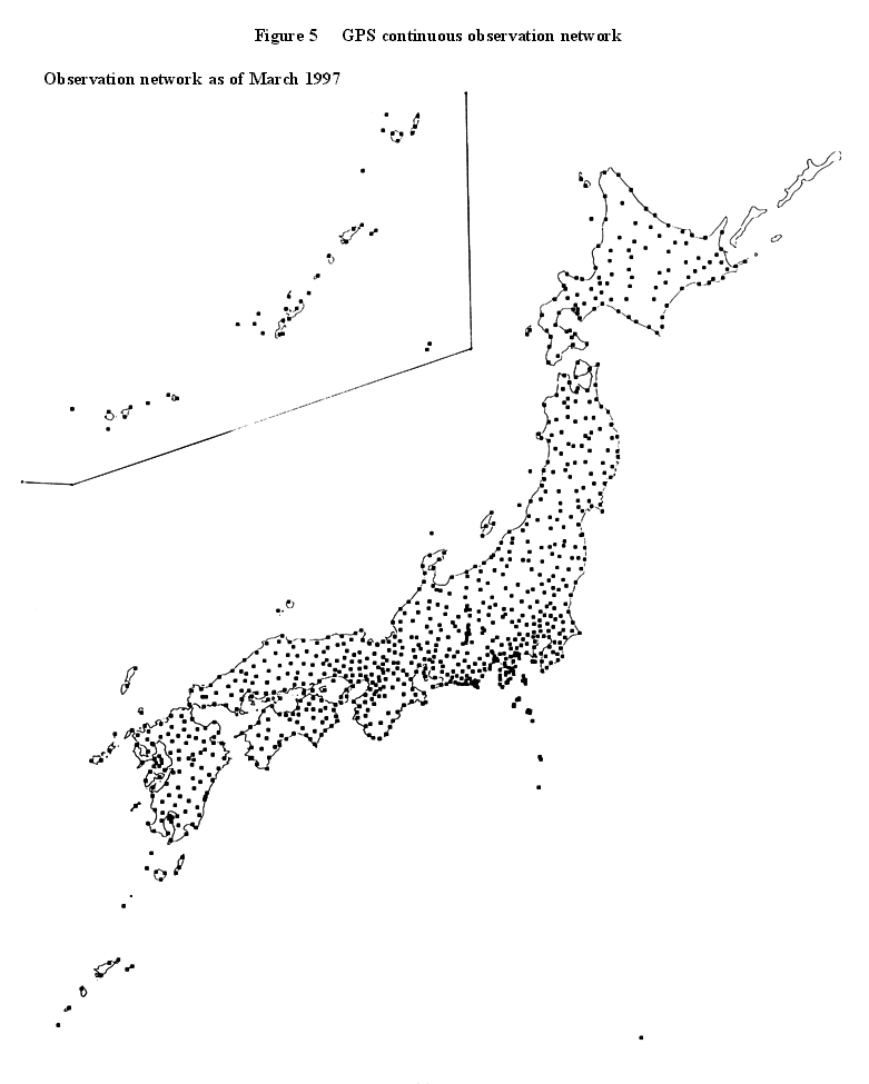
Observation network Fundamental Survey and Observation (in the case of about 20 km interval)
![]()
![]()